|
More death in Haiti tonight as Tropical Cyclone GRACE floods the Earthquake Zone Aug 16, 2021 |
News
HaitiAction.net
|
||||
 |
 |
 |
 |
 |
 |
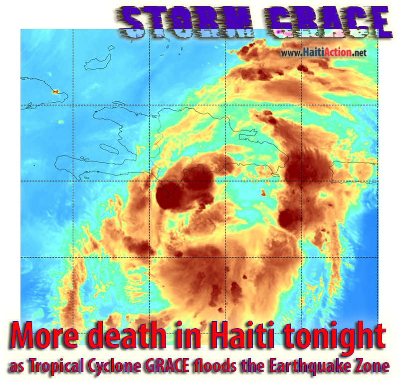 |
| Atlantic Tropical Cyclone #7 — GRACE — satellite image from GOES-16 of the vapor intensity this morning. NRL SATPRODUCTS/TC |
More death in Haiti tonight
as Tropical Cyclone GRACE floods the Earthquake Zone
 |
| On RT #7 in the mountains between Les Cayes and Jeremie is the coffee growing Ville de Beaumont whish saw heartbreaking death and destruction ©2021 HIP |
 |
| Part of the coffee cooperative in Ville de Beaumont, Enyway grew up in the community was flattened. They will need a lot of assistance rebuilding from two generations of work that was lost in an instant ©2021 HIP |
 |
| As the outer bands of Storm GRACE pass over Port au Prince, the residents are troubled with the outlook for their families to the west. ©2021 Teledyol / Patrice Celestine |
by Randall White
HaitiAction.net - Port au Prince, Haiti — As the outer bands of the tropical cyclone GRACE are passing over the downtown of Port au Prince, Haiti — its resident are becoming increasingly worried about the safety of friends and families to the west in the Earthquake Zone. Even mildly impacted communities will be overwhelmed by deadly mudslides and flash floods in the darkness of the stormy night, expected to dump as much as 15 inches of rain in the higher, steep mountainous regions.
Of course, the water will run down into the more populous areas below. The confluence of today’s dry riverbeds will be quickly transformed into deadlier flash floods overnight that could take thousands by surprise. Major roads and communications are down nearer to the epicenter and most are just dealing with the earthquake devastation and will be unaware of the magnitude of the approaching storm.
On top of that another storm of disaster relief parasites are already profiteering off of any goodwill that was intended to reach into the Southern Departments to help the recovery.
Tropical Storm GRACE was predicted to turn northerly after departing from Puerto Rico a couple days ago. However, a subtropical ridge building to the North, is keeping the track more westerly at 13mph. The wind speeds should stay just below Tropical Storm strength, but the vapor levels are significant and the heavier rains will not ease up.
From the Atlantic Tropical Weather Discussion of the NHC in Miami, FL
Tropical Depression Grace is centered near 17.4N 70.2W at 16/0900 UTC or 140 nm east-southeast of Port Au Prince, Haiti, moving W at 13 kt. Estimated minimum central pressure is 1010 mb. Maximum sustained wind speed is 30 kt with gusts to 40 kt. Numerous moderate isolated strong convection is noted from 14N to 19N between 66W and 72W, including the Mona Passage. A general westward or west-northwestward motion is expected over the next few days. On the forecast track, Grace will move over Hispaniola later today, near or over eastern Cuba on Tuesday, and near or just south of west-central Cuba on Wednesday.
Tropical Depression Grace
Discussion Number 13
1100 AM EDT Mon Aug 16 2021
Air Force Reserve and NOAA Hurricane Hunters were both able to locate a center for Grace--probably the most well-defined center observed over the past few days. That center now appears to be moving onshore along the Barahona Peninsula of the Dominican Republic as we speak. The planes measured several possible areas of tropical-storm-force winds from the SFMR, however these observations have not been supported by the more reliable 925-mb flight-level winds for weaker systems, which were only as high as 38 kt, and warrant maintaining the 30-kt initial intensity. Dropsonde data indicate that the central pressure has fallen to 1007 mb.
The aircraft fixes confirm that Grace is moving westward, or 280/13 kt. High pressure over the western Atlantic is forecast to slide westward over the southeastern United States during the next several days, which should keep Grace on a westward to west- northwestward trajectory for the entire 5-day forecast period. This scenario is agreed upon by all of the available track models, and the new NHC track forecast has only been nudged slightly southward from the previous forecast based on the latest consensus aids.
Grace's intensity forecast remains complicated by interaction with land and the possibility of some westerly shear during the forecast period. However, the southern shift in the forecast track takes the center of Grace more definitively over very warm 30 degrees Celsius waters in the northwestern Caribbean Sea. Therefore, gradual strengthening is anticipated while Grace approaches the Yucatan coast of Mexico. Once the system reaches the Gulf of Mexico, the shear appears to decrease, and conditions there will likely be conducive for additional strengthening. In fact, many of the models, including the consensus aids, bring Grace to hurricane intensity, and the NHC intensity forecast has therefore been bumped upward, bringing Grace very near hurricane strength by the end of the forecast period.
Key Messages:
1. Heavy rainfall across the Dominican Republic, Haiti, Cuba, Jamaica, and the Cayman Islands may lead to flash, urban, and small stream flooding, with the potential for mudslides highest in Haiti and the Dominican Republic.
2. Tropical storm conditions are possible over portions of Hispaniola today and tonight, and over Jamaica on Tuesday. Tropical storm conditions are expected over portions of the southern coast of Cuba on Tuesday, spreading westward to the Cayman Islands and other portions of the southern coast of Cuba Tuesday evening through Wednesday morning.
3. There is a increasing risk of wind and rainfall impacts over the Yucatan Peninsula of Mexico Wednesday night and Thursday. Interests there areas should monitor the progress of Grace and updates to the forecast.
FORECAST POSITIONS AND MAX WINDS
INIT 16/1500Z 17.7N 71.4W 30 KT 35 MPH
12H 17/0000Z 18.2N 73.4W 30 KT 35 MPH...S COAST OF HAITI
24H 17/1200Z 18.8N 76.2W 35 KT 40 MPH
36H 18/0000Z 19.4N 79.0W 40 KT 45 MPH
48H 18/1200Z 20.1N 82.1W 45 KT 50 MPH
60H 19/0000Z 20.9N 85.2W 50 KT 60 MPH
72H 19/1200Z 21.6N 88.4W 50 KT 60 MPH...N COAST OF YUCATAN
96H 20/1200Z 22.5N 94.0W 60 KT 70 MPH
120H 21/1200Z 23.0N 98.0W 60 KT 70 MPH...INLAND $$ Forecaster Berg
Share this story with your networks
SEE ALSO
Contact: info@haitiaction.org
Haiti’s latest Coup d’État: Mercenaries assassinate President Jovenel Moïse in the dead of night Jul 7, 2021
"Haiti government complicit in La Saline Massacre"
Dec 4 2018
Lavalas Press Release - Haiti Petrol Crisis Friday
Jul 7 2018
Haiti’s Fanmi Lavalas will continue their mobilization
Oct 6 2014
Prisoners of Sugar May 7 2014
1,500 Cholera victims in Haiti file lawsuit against UN in New York today Mar 11 2014
UN Peacekeeper Misconduct in Haiti: panel discussion this Wednesday in Washington, DC Feb 24 2014
Lovinsky Pierre Antoine
We are not Ghosts and will not be silenced July 19 2007
In Haiti, thousands of Lavalas sing "Aristide or Death!" Jan 9 2013
Is the US Embassy in Haiti behind the political tensions? Jan 5 2013
Haiti: Where is the Money? - Researcher Version Jan 4 2012
La Gavage: Obama helps Republican militarists take control in Haiti
May 13 2011
Haiti's close call: Hurricane IRENE scrapes the Mossad Coast before heading north Aug 22 2011
Hurricane MARIA could threaten Haiti next week Sep 6 2011
Haiti could kill EMILY's strength, but many in camps will still have a sleepless night Aug 3 2011
Haiti: Alarming resurgence of cholera Jun 9 2011
The return of President Aristide to his home in Haiti Mar 20 2011
Haiti: MSF Nears 100,000 Cholera Patients Treated Jan 18 2011