|
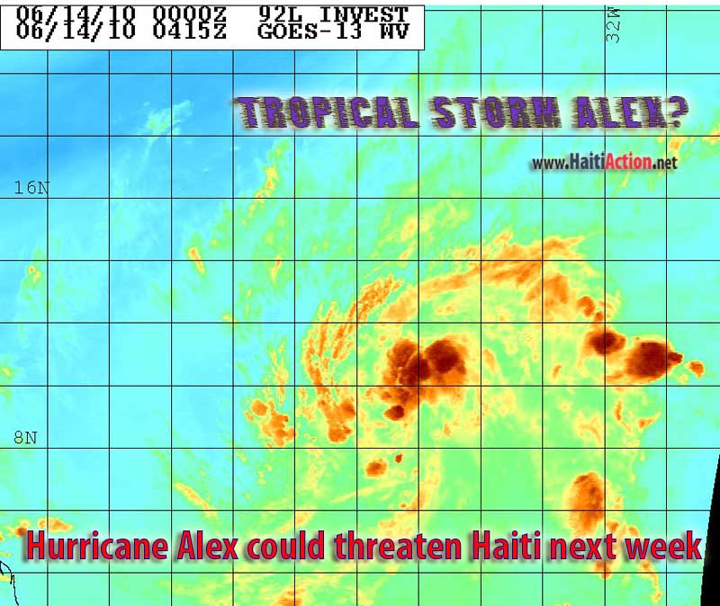
Hurricane Alex could threaten Haiti next week
June 14, 2010 |
News
HaitiAction.net |
||||
| click image for larger view |
 |
 |
 |
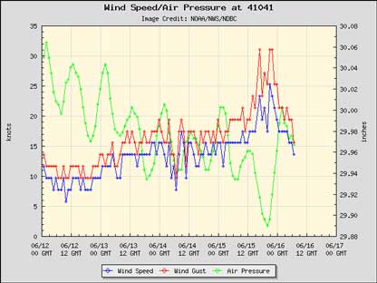 |
| The wind/pressure chart of NOAA Mid-Atlantic weather buoy clearly shows that Storm ALEXIS may have already become a tropical storm. 92L is expected to weaken according to the National Hurricane Center |
UPDATED 3:00 am June 16, 2010
Hurricane Alex could threaten Haiti next week
Haiti Action.net - Port au Prince, Haiti -
June 14 — Today's downpour in Haiti was, yet another, reminder that this summer is forecast to be one of the worst hurricane seasons in the last one hundred years. What it doesn't warn the displaced residents in the streets of Port au Prince is that — as early as Monday, June 21st — Haiti may stand directly in the path of what could be Hurricane ALEX. In the middle of Hurricane Alley 2400 miles away a "broad area of cyclonic circulation" — currently, 92L Invest — has a high probability of becoming tropical depression in the next 48 hours according to the National Hurricane Center (NHC) in Miami, Florida.
ALEX will be the first named storm in what is expected to be a very busy 2010 Atlantic Hurricane Season. Another broad region of thunderstorms moving off of the west coast of Africa shows another ominous pattern that could develop into another tropical cyclone before ALEX hits the Windward Islands. Currently, the upper level winds of the Eastern Caribbean could weaken ALEX once it passes the Windward Islands.
UPDATE: Wednesday June 16, 2010 - 3:30am
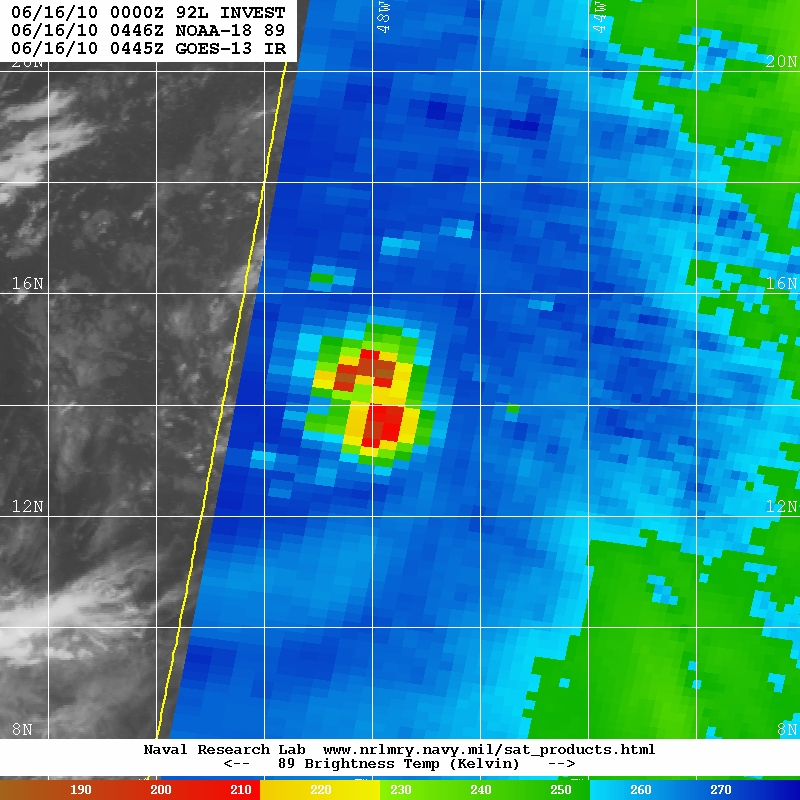
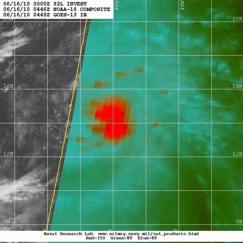
92L has become better organized as it passed within 50 miles of the Mid-Atlantic Weather buoy which showed wind gusts — 50 miles away from the center — had increased to 30kts (34.5mph). After which, the NHC Forecaster Wallace has lowered the chance to 10% that this storm will become a tropical cyclone in the next 48 hours (2:05 AM Tropical Weather Discussion of June 16). NHC forecasters are very reluctant to name a storm that they believe could dissipate, just as quickly as it appeared.
In actuality the winds closer to the center of the storm have, most likely, well exceeded the 39mph threshold to become a tropical storm. Satellite images even show that (shall we call it ALEXIS for the time being?) Tropical Cyclone 92L may have even formed an eye-wall. The next NHC forecast is due at 8:05 AM and could show a more accurate assessment.
UPDATE: Tuesday June 15, 2010 - 10:30am
The weather system of this article 92L has been downgraded — by the NHC — from "high probability" (60%) to "medium chance" (30%) of the system developing into a tropical cyclone during the next 48 hours. The system is mostly unchanged over the last two days, but is now headed into less favorable conditions.
The system is still headed towards Haiti at 15mph and will likely bring heavy rainfall and flooding if it arrives near the island next week. In addition 92L is closely followed by a tropical wave that could become more organized into another strong tropical wave — 25W below 11N — if conditions become more favorable.
Had 92L developed into a tropical storm it would have been the first time — in over 100 years — that a "Cape Verde Storm" had formed this early in the Atlantic Hurricane Season, in June. Over tonight, 92L Invest should make a close approach to the NOAA Mid-Atlantic weather buoy.
CARIBBEAN SEA...
A PAIR OF WELL DEFINED TROPICAL WAVES ARE MOVING ACROSS THE
CARIBBEAN SEA BASIN. THE TROPICAL WAVE MOVING ACROSS THE EASTERN
CARIBBEAN SEA FALLS BENEATH AN UPPER LEVEL DIFFLUENT ENVIRONMENT
ON THE WESTERN PERIPHERY OF AN ANTICYCLONIC CIRCULATION CENTERED
IN THE TROPICAL NORTH ATLC NEAR 13N59W IN THE VICINITY OF
BARBADOS. NUMEROUS MODERATE AND SCATTERED STRONG CONVECTION IS
ASSOCIATED WITH THE WAVE FROM 10N-18N BETWEEN 64W-70W WITH
SCATTERED SHOWERS COVERING THE REMAINDER OF THE AREA EASTERN
CARIBBEAN BETWEEN 61W-73W. THE OTHER TROPICAL WAVE EXTENDS FROM
CENTRAL CUBA TO THE WEST OF JAMAICA NEAR 18N79W TO 14N78W. THIS
WAVE IS LOCATED BENEATH AN UPPER LEVEL LOW CENTERED OVER THE
CENTRAL BAHAMAS NEAR 23N76W WITH AN UPPER LEVEL TROUGH AXIS
EXTENDING SW TO THE YUCATAN PENINSULA NEAR 20N88W. LOW-LEVEL
CONVERGENCE AND INSTABILITY ASSOCIATED WITH THE WAVE COUPLED
WITH UPPER LEVEL DIFFLUENCE EAST OF THE UPPER LEVEL TROUGH AXIS
IS GENERATING A SCATTERED SHOWERS AND TSTMS WITHIN 60 NM OF A
LINE FROM 19N78W TO 22N84W. THE SOUTHERN EXTENT OF THE TROPICAL
WAVE FALLS BENEATH AN UPPER LEVEL RIDGE AXIS EXTENDING FROM
SOUTHERN MEXICO ACROSS GUATEMALA TO NEAR 14N78W. AN UPPER LEVEL
DIFFLUENT PATTERN EXISTS ACROSS THE SW CARIBBEAN AND IS
GENERATING SCATTERED SHOWERS AND TSTMS S OF 18N BETWEEN 74W-86W.
ZCZC MIATWOAT ALL
TTAA00 KNHC DDHHMM
TROPICAL WEATHER OUTLOOK
NWS TPC/NATIONAL HURRICANE CENTER MIAMI FL
200 PM EDT MON JUN 21 2010
FOR THE NORTH ATLANTIC...CARIBBEAN SEA AND THE GULF OF MEXICO...
1. A LARGE AREA OF SHOWERS AND THUNDERSTORMS OVER THE EASTERN CARIBBEAN
SEA IS ASSOCIATED WITH A STRONG TROPICAL WAVE THAT IS MOVING
WESTWARD AT 10 TO 15 MPH. ALTHOUGH THERE IS NO EVIDENCE OF A
SURFACE CIRCULATION...THIS SYSTEM IS SHOWING SOME SIGNS OF
ORGANIZATION AND ENVIRONMENTAL CONDITIONS APPEAR CONDUCIVE FOR
GRADUAL DEVELOPMENT DURING THE NEXT COUPLE OF DAYS. THIS WAVE
COULD PRODUCE LOCALLY HEAVY RAINFALL AND GUSTY WINDS OVER PORTIONS
OF NORTHERN VENEZUELA...THE NETHERLANDS ANTILLES...PUERTO
RICO...THE DOMINICAN REPUBLIC...AND HAITI OVER THE NEXT DAY OR SO.
THERE IS A MEDIUM CHANCE...30 PERCENT...OF THIS SYSTEM BECOMING A
TROPICAL CYCLONE DURING THE NEXT 48 HOURS.
ELSEWHERE...TROPICAL CYCLONE FORMATION IS NOT EXPECTED DURING THE
NEXT 48 HOURS.
$$
FORECASTER BLAKE
NNNN
BOOKMARK the Haiti Action.net Tropical Cyclone Page for latest updates during this hurricane season. HaitiAction.net will host this page with many Tropical Cyclone resources so you can find the latest information when you are searching for current updates.
Contact us: info@haitiaction.org
BOOKMARK the Haiti Action.net Tropical Cyclone Page for latest updates during this hurricane season.
see also
"We want our voices to be heard":
Democracy in Haiti's Earthquake Zone May 3
Haiti: Mobile schools in the Earthquake Zone Apr 3
Protesters clash with police following rain in Haiti Feb 11
If Obama can do it then why can't Haiti's Preval? Feb 9
Haiti: hell and hope Jan 28
On the ground in Port au Prince Jan 28
Haiti News Watch
AP misrepresents reality of Lavalas exclusion in Haiti elections Nov 29
Two-faced Democracy in Haiti
Nov 26
Perverted Priorities: Corpses, sham elections, and sweatshops in Haiti Apr 10
Clinton's 'silence' challenged in Haiti Jul 7
U.N. denials in Haiti Jun 30
Lavalas closed the doors again, elections in Haiti a disaster for Lespwa government Jun 27
"Thank you Bill Clinton" — one more assassination by UN troops in Haiti Jun 20

Contact us: info@haitiaction.org