|
Storm Bonnie takes birth over Haiti
July 20, 2010 |
News
HaitiAction.net |
||||
 Storm Bonnie takes birth over Haiti
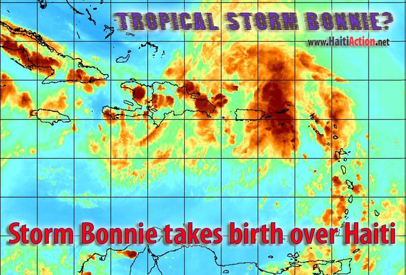
Haiti Action.net - By tonight, locally heavy rains are expected to hit the beleaguered earthquake camps of Haiti. The National Hurricane Center (NHC) of Miami gives the high potential disturbance — currently designated as 97L Invest — a "High" chance of developing into a tropical depression. Currently the "vigorous" weather system does not have a complete closed circulation, if it strengthens past 39mph sustained winds that mark a tropical storm it will become the second named storm — BONNIE — of the 2010 Atlantic Hurricane Season.
Heavy rain throughout Haiti will begin overnight and increase through this Friday. Total rainfall for this period could exceed 6 inches in the northern mountains. Dangerous flash floods and mudslides are possible. The earthquake camps are not ready for severe weather conditions. Even the ShelterBox tents of the lucrative — for Haiti business elites — Colony Corail-Cesselesse were no match for a smaller storm last week. Colony Corail is where the chain-smoking Hollywood activist-cum-humanitarian, Sean Penn, encouraged many displaced Haitians — that were in upscale Petionville — to move into. About 344 tents were totally ripped apart in mere "windy conditions" even though they were the subject of intensive publicity by USAID as being "storm resistant." A few of the Colony Corail inmates were "overheard" saying that they would gladly swap their luxurious digs with Sean Penn's.
It is possible that this storm could strengthen into a tropical storm over Haiti as the conditions are favorable for quick development on its current forecast track. The NOAA's National Climatic Data Center calculated that June's average temperature was the warmest June on record — 1.22°F (0.68°C) above the 20th century average of 59.9°F (15.5°C). While the 2010 Hurricane season has been relatively quiet, from tropical cyclones, there has been a steady stream of tropical waves marching across Hurricane Alley into the Caribbean.
RAW
Share this story with your networks
BOOKMARK the Haiti Action.net Tropical Cyclone Page for latest updates during this hurricane season. HaitiAction.net will host this page with many Tropical Cyclone resources so you can find the latest information when you are searching for current updates.
Contact us: info@haitiaction.org
BOOKMARK the Haiti Action.net Tropical Cyclone Page for latest updates during this hurricane season.
000
WTNT43 KNHC 221503
TCDAT3
TROPICAL DEPRESSION THREE DISCUSSION NUMBER 1
NWS TPC/NATIONAL HURRICANE CENTER MIAMI FL AL032010
1100 AM EDT THU JUL 22 2010
THE TROPICAL WAVE/DISTURBANCE THAT NHC HAS BEEN TRACKING FOR THE
PAST SEVERAL DAYS ACROSS THE ATLANTIC HAS DEVELOPED A SURFACE
CIRCULATION AND ENOUGH ORGANIZED CONVECTION TO BE CLASSIFIED AS A
TROPICAL DEPRESSION. THE DEPRESSION IS SHEARED AT THIS TIME AND ITS
CENTER IS LOCATED ON THE SOUTHWEST SIDE OF A CYCLONICALLY CURVED
CONVECTIVE BAND. THE SHEAR APPEARS TO BE RELAXING A
LITTLE...HOWEVER...AS INDICATED BY THE MOTION OF THE HIGH CLOUDS ON
HIGH RESOLUTION IMAGES. THE CYCLONE IS STILL INTERACTING WITH A
STRONG WESTWARD-MOVING UPPER LOW TO THE WEST. THIS PATTERN WOULD
ONLY ALLOW THE DEPRESSION TO STRENGTHEN A LITTLE AS INDICATED IN
THE OFFICIAL FORECAST...BUT THIS FORECAST IS UNCERTAIN. IN FACT...
NONE OF THE MODELS SHOW SIGNIFICANT INTENSIFICATION.
BECAUSE THE CENTER JUST FORMED...THE INITIAL MOTION IS UNCERTAIN.
THE BEST ESTIMATE IS TOWARD THE WEST-NORTHWEST OR 295 DEGREES AT 13
KNOTS. GLOBAL MODELS FORECAST A WELL-ESTABLISHED SUBTROPICAL RIDGE
EXTENDING FROM THE ATLANTIC WESTWARD ACROSS THE SOUTHERN UNITED
STATES. THIS STEERING PATTERN SHOULD KEEP THE CYCLONE ON A GENERAL
WEST-NORTHWESTWARD TRACK THROUGH 3 TO 4 DAYS ACROSS THE FLORIDA
STRAITS AND THE KEYS AND THEN INTO THE GULF OF MEXICO. BECAUSE THE
RIDGE IS FORECAST TO STRENGTHEN...THE CYCLONE SHOULD BEGIN TO
INCREASE ITS FORWARD SPEED. THE TRACK GUIDANCE IS TIGHTLY CLUSTERED
THROUGH 4 OR 5 DAYS...ALTHOUGH SOME MODELS WEAKEN THE CYCLONE
EARLIER.
AN AIR FORCE PLANE WILL BE IN THE AREA THIS AFTERNOON AND WILL HELP
TO DETERMINE IF THE SYSTEM HAS BECOME A TROPICAL STORM.
FORECAST POSITIONS AND MAX WINDS
INITIAL 22/1500Z 21.9N 75.0W 30 KT
12HR VT 23/0000Z 22.6N 76.8W 35 KT
24HR VT 23/1200Z 23.8N 80.0W 40 KT
36HR VT 24/0000Z 25.0N 83.2W 40 KT
48HR VT 24/1200Z 26.0N 86.5W 40 KT
72HR VT 25/1200Z 28.0N 91.5W 45 KT
96HR VT 26/1200Z 31.0N 94.0W 25 KT...INLAND
120HR VT 27/1200Z 33.0N 95.0W 20 KT...POST-TROP/REMNT LOW
$$
FORECASTER AVILA/ROBERTS
see also
Pursued by France for Haiti Hoax, group holds press conference in Montreal Jul 21
Thousands in Haiti march on Aristide's birthday Jul 16
"We want our voices to be heard":
Democracy in Haiti's Earthquake Zone May 3
Haiti: Mobile schools in the Earthquake Zone Apr 3
Protesters clash with police following rain in Haiti Feb 11
If Obama can do it then why can't Haiti's Preval? Feb 9
Haiti: hell and hope Jan 28
On the ground in Port au Prince Jan 28
Haiti News Watch
AP misrepresents reality of Lavalas exclusion in Haiti elections Nov 29
Two-faced Democracy in Haiti
Nov 26
Perverted Priorities: Corpses, sham elections, and sweatshops in Haiti Apr 10
Clinton's 'silence' challenged in Haiti Jul 7
U.N. denials in Haiti Jun 30
Lavalas closed the doors again, elections in Haiti a disaster for Lespwa government Jun 27
"Thank you Bill Clinton" — one more assassination by UN troops in Haiti Jun 20

Contact us: info@haitiaction.org