|
Hurricane Colin could threaten Haiti this week
August 2, 2010 |
News
HaitiAction.net |
||||
Hurricane Colin could threaten Haiti this week
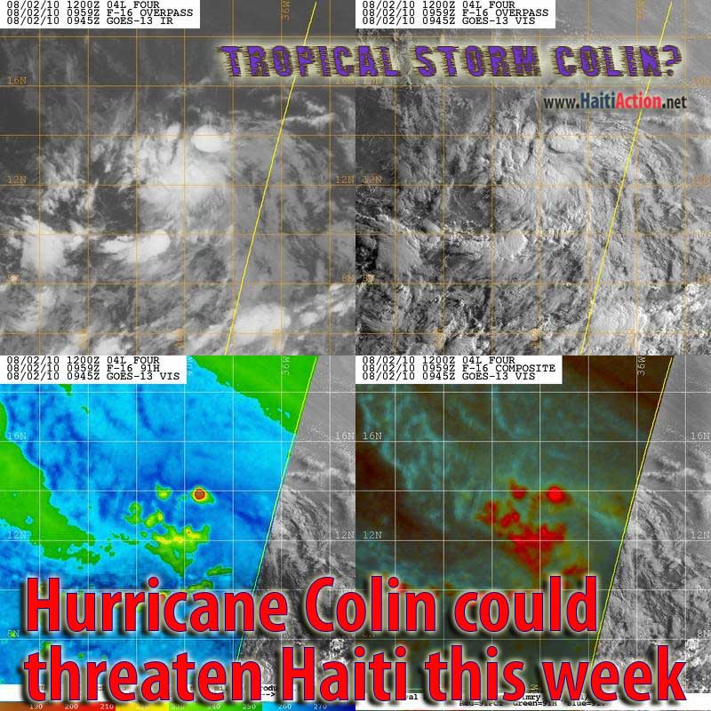
| click image for larger view |
 |
| Tuesday Aug 3 Noon - Tropical Storm COLIN about 200 miles west of the NDBC Mid-Atlantic Buoy. Next buoy 300 miles to the west of the storm. |
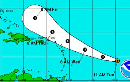 |
| Official NHC track and most models still showing Colin turning north of Haiti as of Wednesday morning. |
Storm Colin has degenerated into a Remnant LOW
UPDATED: Tuesday Aug 3 1522
Haiti Action.net - Port au Prince, Haiti — The heavy showers this week in Haiti's capital portends what could be the first deadly hurricane to hit the beleaguered nation this year. The National Hurricane Center (NHC) in Miami, Florida announced at 11 AM EST that the new weather system has developed into Tropical Depression Four when sustained winds pass 39 MPH the system will become COLIN — the third named storm of the 2010 Atlantic Hurricane season. Even though most prediction models show the expected tropical storm curving north of Haiti, the strain sub-tropical ridge to the north and the steering currents should give the fast moving tropical cyclone a more westerly heading soon — and is just as likely to bring the system directly into the Caribbean.
The NHC stated that the scattered convection now has a well-defined surface center of circulation and has a 64% chance of becoming Tropical Storm Colin today. The initial intensity is currently set at 35 MPH. The NHC is hedging its bets on the forecast track and is already reminding the watchers that the "average error" could be 300 miles off in a few days. This rare statement probably means that they are still rushing to wake up the snoozing prediction community from a relatively quiet start on what was predicted to be a busy hurricane season.
The system could move directly over the NDBC Mid-Atlantic Buoy overnight which could provide a clearer assessment of the actual storm's strength.
Currently, the NHC is expecting the storm to increase in forward speed if it stays on a northwest curvature. If that happens, and if the cyclone does not intensify in the next day or so, it could "struggle to maintain a closed surface circulation" with the combined forward speed and the wind shear developing to the north. A more westerly direction would keep Storm COLIN over warmer waters and within environmental conditions favorable to further development of this storm. The next 72 hours should have civil defense agencies in Haiti closely watching the progress of this storm.
RAW
View the latest observations near Atlantic TROPICAL STORM COLIN
Share this story with your networks
BOOKMARK the Haiti Action.net Tropical Cyclone Page for latest updates during this hurricane season. HaitiAction.net will host this page with many Tropical Cyclone resources so you can find the latest information when you are searching for current updates.
Contact us: info@haitiaction.org
BOOKMARK the Haiti Action.net Tropical Cyclone Page for latest updates during this hurricane season.
000
WTNT44 KNHC 031438
TCDAT4
TROPICAL STORM COLIN DISCUSSION NUMBER 5
NWS TPC/NATIONAL HURRICANE CENTER MIAMI FL AL042010
1100 AM EDT TUE AUG 03 2010
COLIN HAS A VERY RAGGED APPEARANCE THIS MORNING. THE CONVECTIVE
BANDING SEEN EARLIER HAS WEAKENED...LEAVING A SMALL CONVECTIVE MASS
NEAR THE CENTER AND A SECOND CONVECTIVE MASS TO THE NORTH.
SATELLITE INTENSITY ESTIMATES ARE 35 KT FROM TAFB AND 30 KT FROM
SAB...AND BASED ON THIS THE INITIAL INTENSITY REMAINS 35 KT. IT
SHOULD BE NOTED THAT IT IS HARD TO FIND WESTERLY WINDS IN THE LOW
CLOUD MOTIONS SOUTH OF THE CENTRAL CONVECTION...AND THERE IS SOME
QUESTION AS TO WHETHER COLIN STILL HAS A CLOSED CIRCULATION.
THE SYSTEM HAS TURNED A LITTLE TO THE LEFT DURING THE PAST SEVERAL
HOURS. THE INITIAL MOTION IS 280/21...AND THE SHORT-TERM MOTION
MAY BE EVEN FASTER. COLIN IS ON THE SOUTH SIDE OF THE LOW/
MID-LEVEL BERMUDA HIGH...AND IN 48-72 HR SHOULD BE APPROACHING A
WEAKNESS OR BREAK IN THE HIGH CAUSED BY A MID/UPPER-LEVEL TROUGH
NEAR THE SOUTHEASTERN COAST OF THE UNITED STATES. THIS PATTERN
SHOULD INITIALLY STEER COLIN RAPIDLY TOWARD THE WEST-NORTHWEST...
FOLLOWED BY A TURN TOWARD THE NORTHWEST WITH A DECREASE IN FORWARD
SPEED AFTER 48 HR. THE MODEL GUIDANCE GENERALLY AGREES WITH THIS
SCENARIO. HOWEVER...THERE IS A CONSIDERABLE SPREAD IN THE TRACKS
BY THE END OF THE FORECAST PERIOD. THE GFDL AND HWRF FORECAST AN
EAST OF NORTH MOTION ON THE RIGHT EDGE OF THE GUIDANCE ENVELOPE BY
120 HR...WHILE THE CANADIAN AND GFDN ARE ON THE LEFT EDGE WITH NO
NORTHWARD TURN BEFORE 120 HR. THE NEW FORECAST TRACK IS SHIFTED
60-90 N MI TO THE SOUTHWEST BASED ON THE INITIAL POSITION AND
MOTION. IT IS IN BEST AGREEMENT WITH THE ECMWF AND LIES TO THE
LEFT OF THE CONSENSUS MODELS AND THE CENTER OF THE GUIDANCE
ENVELOPE.
CURRENTLY...COLIN IS EXPERIENCING WESTERLY VERTICAL SHEAR LIKELY
CAUSED BY THE LOWER PART OF THE STORM OUTRUNNING THE UPPER PART.
THIS IS FORECAST TO CONTINUE FOR THE NEXT 24-36 HR DUE TO THE RAPID
MOTION. AFTER THAT TIME...THE SYSTEM IS EXPECTED TO ENCOUNTER
INCREASING UPPER-LEVEL WESTERLY WINDS CAUSED BY THE WESTERN
ATLANTIC TROUGH. THIS PATTERN DOES NOT APPEAR FAVORABLE FOR
SIGNIFICANT STRENGTHENING...AND THE ONLY INTENSITY GUIDANCE THAT
CURRENTLY CALLS FOR COLIN TO BECOME A HURRICANE IS CLIMATOLOGY/
PERSISTENCE. GIVEN THE CURRENT TRENDS AND THE FORECAST SHEAR...THE
INTENSITY FORECAST IS A LITTLE WEAKER THAN THE PREVIOUS FORECAST...
WITH AN INTENSITY OF 45 KT THROUGH MOST OF THE FORECAST PERIOD. AN
ALTERNATIVE SCENARIO IS THAT COLIN COULD DEGENERATE TO AN OPEN WAVE
DUE TO A COMBINATION OF ITS RAPID MOTION AND WESTERLY SHEAR.
INTERESTS IN THE NORTHERN LEEWARD ISLANDS AND THE VIRGIN ISLANDS
SHOULD FOLLOW THE PROGRESS OF COLIN.
FORECAST POSITIONS AND MAX WINDS
INITIAL 03/1500Z 14.2N 49.5W 35 KT
12HR VT 04/0000Z 15.0N 52.7W 40 KT
24HR VT 04/1200Z 16.5N 56.6W 45 KT
36HR VT 05/0000Z 18.3N 60.4W 45 KT
48HR VT 05/1200Z 20.2N 63.7W 45 KT
72HR VT 06/1200Z 23.0N 67.5W 45 KT
96HR VT 07/1200Z 26.5N 69.5W 45 KT
120HR VT 08/1200Z 29.0N 70.5W 50 KT
$$
FORECASTER BEVEN
see also
Pursued by France for Haiti Hoax, group holds press conference in Montreal Jul 21
Thousands in Haiti march on Aristide's birthday Jul 16
"We want our voices to be heard":
Democracy in Haiti's Earthquake Zone May 3
Haiti: Mobile schools in the Earthquake Zone Apr 3
Protesters clash with police following rain in Haiti Feb 11
If Obama can do it then why can't Haiti's Preval? Feb 9
Haiti: hell and hope Jan 28
On the ground in Port au Prince Jan 28
Haiti News Watch
AP misrepresents reality of Lavalas exclusion in Haiti elections Nov 29
Two-faced Democracy in Haiti
Nov 26
Perverted Priorities: Corpses, sham elections, and sweatshops in Haiti Apr 10
Clinton's 'silence' challenged in Haiti Jul 7
U.N. denials in Haiti Jun 30
Lavalas closed the doors again, elections in Haiti a disaster for Lespwa government Jun 27
"Thank you Bill Clinton" — one more assassination by UN troops in Haiti Jun 20

Contact us: info@haitiaction.org