|
Hurricane IGOR will not threaten Haiti, but natural gas futures rise…
September 13, 2010 |
News
HaitiAction.net |
||||
 |
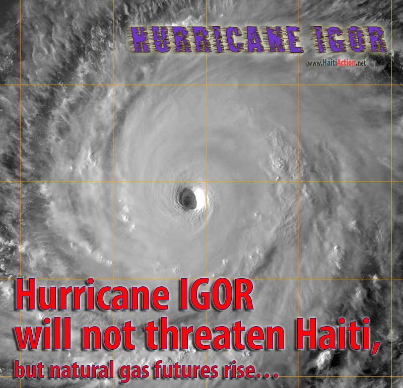
The official ATCF map shows Hurricane IGOR headed well away from Haiti, but a real threat to Bermuda. Most models have been similar to this track for over five days. CLICK IMAGES FOR LARGER VIEW |
 |
| As of 9PM AST the Daily Telegraph story was unchanged — unlike the petroleum market futures. |
Hurricane IGOR will not threaten Haiti, but natural gas futures rise…
Story updated Noon Sep 14 AST
Haiti Action.net - Port au Prince, Haiti — Contrary to a news article in the UK's Daily Telegraph, Hurricane IGOR is not expected to threaten Haiti this week. The Category 4 Hurricane IGOR has begun turning northwest away from the threatening westerly track — 270º — over the last few days. The National Hurricane Center in Miami (NHC) stated this afternoon:
"The initial motion is still due west...270 degrees...at 9 knots. All of the guidance...except the UKMET…insists on a turn toward the west-northwest in the next 12 hours as IGOR begins to move into a large weakness in the subtropical ridge. However…due to the initial position and motion...the official forecast has again been adjusted a little to the left of the previous advisory through 48 hours."
Some analysts have speculated that the uncharacteristic attention on Haiti's natural disaster risk may have been seeded by other interests who are supplying the "irrational exuberance" seen in the markets and petroleum futures over the last couple of weeks with the required market hype. The news seems to be displacing Invest 92L releases with IGOR news. In a volatile market most of the trading interests won't pick up on the error and make trading decisions based on the disinformation.
It should be noted that the NOAA — for its part — has not, publicly, been behind the IGOR rumors even though they claim that "The NOAA … plays several distinct roles within the Department of Commerce…"
The article which was published, in time, for the US markets opening seem to have several glaring fabrications:
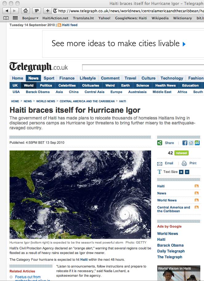
1. "The Category Four hurricane is expected to hit Haiti within the next 48 hours."
That seems to be the exact opposite of what is on the Centre national de météorologie (CNM) website: "L'ouragan Igor évolue sur l'ocean atlantique à plus de 1000 Km à l'est de l'arc Antillais. Il n'est pas prévu de menacer Haïti." HaitiAction.net has been looking but still unable to find any credible agency that has been predicting that IGOR will come within 1000 miles of Haiti.
2. "Haiti's Civil Protection Agency declared an "orange alert," warning that several regions could be flooded as a result of heavy rains expected as Igor drew nearer."
There was an Orange Alert, in response to the anemic 92L, that was lifted this morning. Even though the NHC alerts on 92L were a bit conflated, it was good to see that Haiti's agencies responded appropriately — as far as French Language press releases go — to the authoritative NHC alerts.
3. "'Listen to announcements, follow instructions and prepare to relocate if it is necessary,' said Nadia Lochard, a spokeswoman for the agency."
While this quote may have been an accurate rendition of what the agency rep said to a member of the international press, it raises many reasonable questions. More than any, if that was announced from a sound truck to an Earthquake Survivor Camp; just where were you expecting the tens of thousands — that might possibly hear such a message — to "relocate" to?
In addition to speeding up a bit and turning northwest — 295º — Hurricane IGOR may also reach an intensity of Category 5 on the Saffir-Simpson Scale (> 155 mph - > 135 kt - > 249 km/hr). It is rare that a tropical cyclone that travels north of the Mid-Atlantic weather buoy threatens populations west of the outer Leeward Islands with anything more than heavy surf (heavy surf is predicted to begin on Wednesday morning). If IGOR moves above 20º N over the next 36 hours, the likelihood becomes more of a certainty.
It's even more rare that members of the corporate media take any specific interest in Haiti's vulnerability to approaching storms this early in the forecast track and, especially, with a contrarian analysis.
IGOR is expected to weaken somewhat as it heads north, speeds up forward motion and heads into a major dry air patch above the subtropical ridge — which would belie the spin in a misleading AFP release. The current forecast track has Hurricane IGOR headed directly towards Bermuda and could arrive there as a Category 2 Hurricane. The other major storm in the Atlantic — which also played into the "financial news" matrix — Hurricane Julia will assist the surfers along North Africa and Europe. It is expected to move in a northwesterly track in the next 12 hours and turn north into the center of the North Atlantic.
On the other hand, if Hurricane IGOR returns to a westerly track for another 24 hours we will all see a major independent adaption by almost all prediction models. HaitiAction.net will be closely following the progress of IGOR through the next week.
RAW
View the latest observations near Storm IGOR
Share this story with your networks
BOOKMARK the Haiti Action.net Tropical Cyclone Page for latest updates during this hurricane season. HaitiAction.net will host this page with many Tropical Cyclone resources so you can find the latest information when you are searching for current updates.
Contact us: info@haitiaction.org
BOOKMARK the Haiti Action.net Tropical Cyclone Page for latest updates during this hurricane season.
000
WTNT41 KNHC 141443
TCDAT1
HURRICANE IGOR DISCUSSION NUMBER 26
NWS TPC/NATIONAL HURRICANE CENTER MIAMI FL AL112010
1100 AM AST TUE SEP 14 2010
THERE HAS BEEN LITTLE CHANGE IN THE STRUCTURE OF IGOR DURING THE
PAST SEVERAL HOURS...WITH THE 20 NM WIDE EYE REMAINING WELL DEFINED
AND EYEWALL CONVECTIVE TOPS REMAINING COLDER THAN -70C. SATELLITE
INTENSITY ESTIMATES ARE UNCHANGED FROM SIX HRS AGO...SO THE INITIAL
INTENSITY REMAINS 115 KT. RECENT MICROWAVE OVERPASSES DO NOT YET
SHOW AN OUTER EYEWALL...BUT DO SHOW THAT A LARGE RAIN-FREE MOAT HAS
FORMED BETWEEN THE EYEWALL AND THE OUTER CONVECTIVE BANDS. THE
CIRRUS OUTFLOW IS GOOD IN ALL DIRECTIONS.
THE INITIAL MOTION IS NOW 290/6. IGOR IS MOVING TOWARD A WEAKNESS
IN THE SUBTROPICAL RIDGED CAUSED BY A BROAD DEEP-LAYER TROUGH OVER
THE NORTHEASTERN UNITED STATES AND THE NORTHWESTERN ATLANTIC. THE
DYNAMICAL MODELS FORECAST THIS WEAKNESS TO PERSIST FOR THE NEXT
SEVERAL DAYS AS A SERIES OF SHORTWAVE TROUGHS MOVE THROUGH THE
BROADER TROUGH. IN ADDITION...THE DYNAMICAL MODELS FORECAST AN
UPPER-LEVEL TROUGH TO DEVELOP NEAR THE SOUTHEASTERN COAST OF THE
UNITED STATES BY 96-120 HR...WITH A LARGE UPPER-LEVEL HIGH FORMING
OVER THE CENTRAL ATLANTIC. THIS EVOLUTION SHOULD STEER IGOR
WEST-NORTHWESTWARD TO NORTHWESTWARD FOR THE NEXT 48-72 HR...
FOLLOWED BY A MORE NORTHWARD MOTION. THE TRACK GUIDANCE IS IN GOOD
AGREEMENT WITH THIS SCENARIO...ALTHOUGH THERE REMAINS SOME SPREAD
BETWEEN THE MORE WESTWARD UKMET/NOGAPS AND THE MORE EASTWARD GFDL.
THE NEW FORECAST TRACK IS SHIFTED A LITTLE TO THE WEST OF THE
PREVIOUS TRACK AND LIES NEAR THE CENTER OF THE GUIDANCE ENVELOPE.
IGOR REMAINS IN AN ENVIRONMENT OF LIGHT VERTICAL WIND SHEAR AND WARM
SEA SURFACE TEMPERATURES...AND THESE CONDITIONS ARE FORECAST TO
PERSIST FOR THE NEXT 48-72 HR. THUS...THE INTENSITY IS LIKELY TO
BE CONTROLLED BY HARD-TO-TIME EYEWALL REPLACEMENT CYCLES DURING
THIS TIME. THE INTENSITY FORECAST CALLS FOR SOME INTENSIFICATION
BY 24 HR ON THE PREMISE THAT THE CURRENT INTERNAL CYCLE WILL BE
COMPLETE. AFTER 72 HR...THE SEA SURFACE TEMPERATURES GRADUALLY
COOL ALONG THE FORECAST TRACK...AND SOUTHERLY UPPER-LEVEL WINDS
BETWEEN THE PREVIOUSLY MENTIONED TROUGH AND HIGH ARE EXPECTED TO
CAUSE INCREASED SHEAR. THESE FACTORS SHOULD CAUSE IGOR TO
GRADUALLY WEAKEN...AND THE NEW INTENSITY FORECAST IS THE SAME AS
THE PREVIOUS FORECAST AT 96-120 HR.
INTERESTS IN BERMUDA SHOULD NOT FOCUS ON THE 5-DAY POINT...SINCE
TRACK ERRORS COULD EASILY BE A FEW HUNDRED MILES AT THAT FORECAST
INTERVAL. IT IS STILL TOO EARLY TO SAY WITH CERTAINTY WHETHER IGOR
WILL HAVE A SIGNIFICANT IMPACT ON THAT ISLAND.
FORECAST POSITIONS AND MAX WINDS
INITIAL 14/1500Z 18.3N 52.3W 115 KT
12HR VT 15/0000Z 18.8N 53.3W 115 KT
24HR VT 15/1200Z 19.8N 54.8W 120 KT
36HR VT 16/0000Z 20.8N 56.3W 120 KT
48HR VT 16/1200Z 21.9N 57.8W 120 KT
72HR VT 17/1200Z 24.5N 61.0W 115 KT
96HR VT 18/1200Z 28.0N 64.0W 100 KT
120HR VT 19/1200Z 32.0N 65.5W 90 KT
$$
FORECASTER BEVEN
see also
Pursued by France for Haiti Hoax, group holds press conference in Montreal Jul 21
Thousands in Haiti march on Aristide's birthday Jul 16
"We want our voices to be heard":
Democracy in Haiti's Earthquake Zone May 3
Haiti: Mobile schools in the Earthquake Zone Apr 3
Protesters clash with police following rain in Haiti Feb 11
If Obama can do it then why can't Haiti's Preval? Feb 9
Haiti: hell and hope Jan 28
On the ground in Port au Prince Jan 28
Haiti News Watch
AP misrepresents reality of Lavalas exclusion in Haiti elections Nov 29
Two-faced Democracy in Haiti
Nov 26
Perverted Priorities: Corpses, sham elections, and sweatshops in Haiti Apr 10
Clinton's 'silence' challenged in Haiti Jul 7
U.N. denials in Haiti Jun 30
Lavalas closed the doors again, elections in Haiti a disaster for Lespwa government Jun 27
"Thank you Bill Clinton" — one more assassination by UN troops in Haiti Jun 20

Contact us: info@haitiaction.org