Tropical Cyclone Page
 HaitiAction.net 
 
About Events Talk News Links Home
 
click for larger image

 Tropical Cyclones 2011
  HaitiAction.net

   use National Hurricane Center page for latest official alerts

TOMAS

Hurricane TOMAS predicted over Haiti by Friday,
or not…

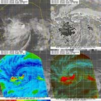
Haiti Action.net - Port au Prince, Haiti — A weakening Tropical Storm TOMAS is currently located 135 miles Northeast of Curaçao and traveling WbS @ 12mph. The National Hurricane Center (NHC) in Miami, Florida sees a strong possibility that TOMAS might not survive the westerly vertical shear if it starts a more northerly turn as most prediction models show.

The consensus models appear to be a lagging indicator and haven't caught up with the unpredicted change in the mid-level ridge, reported on here — HaitiAction.net — Saturday morning. ( A good kick to the servers should straighten things out. ) The NHC — last week — was expecting that the mid-level ridge would be eroded by a developing trough over central Cuba. While the trough is still apparent, the mid-level ridge has had more impact on the trough than vice-versa. The strongest part of the rig has widened out north of Haiti and over Cuba, when it was forecast to simply dissipate as it moved Eastward of the "Hispaniola" island.

All of that atmospheric mumbling may be of little interest to many — including the aforementioned algorithm crunching machines — but it may mean that TOMAS could simply stay on a westerly course for a few days longer and miss the beleaguered nation of Haiti entirely. Instead of moving through the strong vertical shear band, to more favorable hurricane development conditions, the storm dissipati shear has said ahead of Tropical Storm TOMAS and could simply "shred" the cyclone into a disorganized mass of angry wet air.

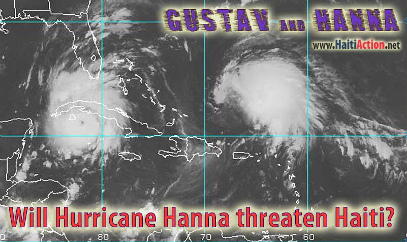
On the other hand, interests in the Windward Islands, especially the Virgin Islands area, are closely monitoring the same models and are providing favorable odds to the HWRF model that was dead on accurate in predicting the U-turn and intensity of Hurricane OMAR in 2008.

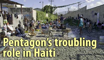
It still remains that TOMAS may travel into Haiti over a few days and dump volumes of rainfall over the southern departments causing deadly mudslides and flash floods. The resulting effects on Haiti's internally displaced can't be simply measured, but, we will be here to report it.

View the latest observations near Hurricane TOMAS

Share this story with your networks

Share this story with your networks

| More

BOOKMARK the Haiti Action.net Tropical Cyclone Page for latest updates during this hurricane season. HaitiAction.net will host this page with many Tropical Cyclone resources so you can find the latest information when you are searching for current updates.

Contact us: info@haitiaction.org

Donate
click button above

BOOKMARK the Haiti Action.net Tropical Cyclone Page for latest updates during this hurricane season.


Bookmark this page for the 2011 Hurricane Season

2011 storm names: Arlene, Bret, Cindy, Don, Emily, Franklin, Gert, Harvey, Irene, Jose, Katia, Lee, Maria, Nate, Ophelia, Philippe, Rina, Sean, Tammy, Vince, Whitney

000 AXNT20 KNHC 301157 TWDAT
TROPICAL WEATHER DISCUSSION NWS NATIONAL HURRICANE CENTER MIAMI FL
805 AM EDT SAT JUL 30 2011


A TROPICAL WAVE IS MOVING ACROSS THE EASTERN TROPICAL ATLC  ANALYZED FROM 19N49W TO A 1008 MB LOW CENTERED NEAR THE SOUTHERN  EXTENT OF THE WAVE NEAR 11N45W. THIS WAVE IS EMBEDDED WITHIN A  BROAD AREA OF DEEP MOISTURE ON TPW PRODUCT. BROAD CYCLONIC FLOW  IS WELL OBSERVED IN THE LOW LEVEL CLOUD PATTERN ON SATELLITE  IMAGERY.  THIS WAVE WARRANTS WATCHING AS SOME MODELS FORECAST  DEVELOPMENT WITH A THREAT TO THE LESSER ANTILLES AND PUERTO  RICO. ENVIRONMENTAL CONDITIONS APPEAR FAVORABLE FOR A TROPICAL  DEPRESSION TO FORM OVER THE NEXT COUPLE OF DAYS. THIS SYSTEM HAS  A HIGH CHANCE OF BECOMING A TROPICAL CYCLONE DURING THE NEXT 48  HOURS AS IT MOVES WEST-NORTHWESTWARD AT 15 TO 20 KT. SCATTERED  MODERATE TO STRONG CONVECTION IS FROM 8N-14N BETWEEN 37W-50W.  THIS AREA OF CONVECTION IS ALSO RELATED TO THE ITCZ.  ...TROPICAL WAVES...  A TROPICAL WAVE IS W OF THE CAPE VERDE ISLANDS ANALYZED FROM  23N30W TO 13N31W MOVING W AT 15 KT. SATELLITE DATA SHOWS  CYCLONIC TURNING ALONG THE WAVE AXIS N OF 18N. THIS WAVE IS  LOCATED ALONG THE LEADING EDGE OF A LOW-MID MOISTURE SURGE  DEPICTED ON TOTAL PRECIPITABLE WATER PRODUCT. HOWEVER...NO  SIGNIFICANT CONVECTION IS NOTED WITH THE WAVE AT THIS TIME.  A TROPICAL WAVE IS MOVING ACROSS THE NW CARIBBEAN...ANALYZED  FROM 23N83W TO 12N82W MOVING W AT 15-20 KT. THE WAVE IS EMBEDDED  WITHIN AN AREA OF DEEP MOISTURE ON TPW PRODUCT. BROAD LOW LEVEL  CLOUD CYCLONIC CURVATURE IS OBSERVED ON SATELLITE DATA. THE WAVE  IS JUST N OF THE MONSOON TROUGH LOCATED ON THE SW CARIBBEAN. THE  COMBINATION OF THESE TWO SYSTEMS IS GENERATING A BROAD AREA OF  CYCLONIC TURNING ACCOMPANIED BY SCATTERED HEAVY SHOWERS AND  THUNDERSTORMS OVER A GREAT PORTION OF THE CENTRAL AND WESTERN  CARIBBEAN W OF 75W...WITH THE STRONGEST CONVECTION WITHIN 150 NM  OFF THE COAST OF HONDURAS. NO SIGNIFICANT DEVELOPMENT IS  EXPECTED WITH THIS WAVE DUE TO INTERACTION WITH LAND. HOWEVER...  LOCALLY HEAVY RAINFALL TO PORTIONS OF CENTRAL AMERICA ARE  EXPECTED THROUGH THE WEEKEND AS THE SYSTEM TRACKS W.  ...ITCZ/MONSOON TROUGH... THE MONSOON TROUGH EXTENDS ACROSS GUINEA-BISSAU IN WEST AFRICA  ENTERING THE ATLC ALONG 12N16W TO 10N20W TO 11N24W. THE ITCZ  CONTINUES FROM THIS POINT TO 12N30W...RESUMING W OF A TROPICAL  WAVE NEAR 12N34W TO 13N44W...THEN RESUMES AGAIN S OF ANOTHER  TROPICAL WAVE NEAR 8N47W TO THE COAST OF GUYANA IN SOUTH AMERICA  NEAR 7N58W. SCATTERED MODERATE TO STRONG CONVECTION IS FROM  7N-14N BETWEEN 30W-60W. THIS AREA OF CONVECTION IS ALSO  ASSOCIATED TO THE TROPICAL WAVE MOVING ACROSS THE EASTERN  TROPICAL ATLC. SCATTERED WEAK TO MODERATE CONVECTION IS WITHIN  200 NM OFF THE COAST OF WEST AFRICA FROM 7N-13N.  ...DISCUSSION...  GULF OF MEXICO... THE REMNANT LOW OF DON IS NOW INLAND OVER SOUTHERN TEXAS. MOST  OF THE CONVECTION ASSOCIATED TO IT HAS MOVED INLAND WITH ONLY A  FEW ISOLATED SHOWERS LINGERING ALONG THE IMMEDIATE COAST OF  SOUTHERN TEXAS AND MEXICO S OF 27N. THE REMAINDER OF THE GULF IS  UNDER THE INFLUENCE OF A VERY DRY AIRMASS ALOFT WITH STRONG  SUBSIDENCE SUPPRESSING DEEP CONVECTION ACROSS THE AREA. JUST A  SMALL CLUSTER OF SCATTERED SHOWERS REMAIN OVER THE BAY OF  CAMPECHE S OF 21N W OF 93W. OTHERWISE...SURFACE RIDGING EXTENDS  FROM NE TO SW ANCHORED BY A 1019 MB HIGH OVER THE SE CONUS. THE  ANTICYCLONIC FLOW AROUND THIS SYSTEM IS MOVING SOME LOW LEVEL  MOISTURE ACROSS THE FLORIDA STRAITS OF 84W WITH SCATTERED WEAK  SHOWERS EMBEDDED IN THE FLOW.  CARIBBEAN SEA... A TROPICAL WAVE MOVES ACROSS THE NW CARIBBEAN. THIS SYSTEM ALONG  WITH THE MONSOON TROUGH IN THE SW CARIBBEAN ARE GENERATING A  BROAD AREA OF SCATTERED HEAVY SHOWERS AND THUNDERSTORMS OVER A  GREAT PORTION OF THE CENTRAL AND WESTERN CARIBBEAN W OF 75W.  THIS AREA OF PRECIPITATION AND MOISTURE IS EXPECTED TO SHIFT  WESTWARD OVER THE NEXT 24 HOURS WITH THE POTENTIAL FOR LOCALLY  HEAVY RAINFALL AND POSSIBLE FLASH FLOODING ACROSS CENTRAL  AMERICA...EXPECTED TO LAST THROUGH THE WEEKEND. THE REMAINDER OF  THE CARIBBEAN BASIN IS EXPERIENCING FAIR WEATHER CONDITIONS WITH  ISOLATED MODERATE TO HEAVY SHOWERS EMBEDDED IN THE MODERATE  EASTERLY TRADE WINDS...ESPECIALLY OVER THE NE CARIBBEAN N OF 14N  E OF 68W.  ATLANTIC OCEAN... ASIDE THE TROPICAL WAVES MOVING ACROSS THE TROPICAL REGION...A  STRONG 1030 MB HIGH PRESSURE SYSTEM DOMINATES THE DISCUSSION  AREA THIS EVENING...ANCHORED WEST OF THE AZORES NEAR 40N35W AND  EXTENDING A RIDGE AXIS SW TO NEAR 28N65W.  FOR ADDITIONAL INFORMATION PLEASE VISIT HTTP://WWW.HURRICANES.GOV/MARINE  $$  GARCIA


From the 2008 archive click image for original Aug 30, 2008 article

Will Hurricane Hanna threaten Haiti? click image for original Aug 30, 2008 article

Previous reports

Hurricane Bill will threaten Haiti this week Aug 17

Hurricane Ana could threaten Haiti next week
(but Hurricane Bill arrived months ago)
 Aug 11

Haiti waits in fear for Hurricane Ike Sep 4

Haiti’s deadly hurricane season just getting started Sep 1

Will Hurricane Hanna threaten Haiti? Aug 30

Dangerous Hurricane Gustav will hit Haiti Aug 25

Haiti's crops will be devastated by Hurricane Gustav Aug 26

Furious Fay floods Florida as a new storm approaches Haiti Aug 21

Furious Tropical Storm Fay drenches Haiti Aug 15


Donate HaitiAction.net
click button above


HaitiAction.net Links Latest Info on Tropical Cyclones for Caribbean
  1. République d'Haiti [French, not Kreyol]
    Communiqué d'activité cyclonique
  2. Haiti-Puerto Rico Visible Satellite Loop
  3. Caribbean/Gulf Satellite movie
    takes a couple minutes to download on DSL
  4. NRL Tropical Cyclone Page
    Monterey Marine Meteorology Division
  5. National Hurricane Center
  6. Barahona Current Weather
  7. Atlantic Total Precipitable Water
    takes a couple minutes to download on DSL
  8. Instituto de Meteorologia - Cuba
  9. Links Meteorólogicos Venezuela
  10. AccuWeather.com - Latest
    Atlantic Satellite Overview
  11. National Weather Service
    Southern USA Region HQ
  12. NRL Tropical Support Page
    NMOC - Norfolk, VA
  13. National Weather Service Forecast Office
    San Juan, Puerto Rico
  14. Granma International - Cuba
  15. Jamaica Observer
  16. Tropical Cyclones
    Cooperative Institute for Meteorological Satellite Studies.
  17. Latest QUICKSCAT Wind vectors
  18. Latest QUICKSCAT Wind speed
  19. NDBC & WMO Buoys
    Station 41041 - Middle Atlantic
    Station 41040 - West Atlantic
    Station 41NT0 - NW Tropical Atlantic
    Station 41101 - East of Martinique

    Station 41043 - NE of Puerto Rico
    Station JOXP4 - Puerto Rico - South

    Station 42059 - Eastern Caribbean
    Station 42058 - Central Caribbean
    Station 42057 - Western Caribbean
    Station 42056 - Yucatan Basin
    Station 42055 - Bay of Campeche
  20. PAP - Weather UnderGround
  21. Meteo France
    Phénomènes cycloniques de l'Atlantique Nord
  22. Jamaica Meterological Service
  23. NASA GOES East Visible - Hurricane Sector
  24. Bahamas
  25. Dominica
    Severe Weather Advisory
  26. República Dominica
  27. Antigua & Barbuda
  28. CDEMA - Saint Lucia
  29. World Meteorological Organization
1 knots = 1.15077945 mph

The Saffir-Simpson Hurricane Scale
What "Category 1-2-3-4-5" means

Key to offical Tracking Chart symbols
click above link to get original Powerpoint file

St. Jean Bosco
march